Import Modules
import sqlalchemy as sa
import geopandas as gpd
import pandas as pd
import matplotlib.pyplot as plt
import contextily as ctx
import math
%matplotlib inline
Database Connection
pg_uri_template = 'postgresql+psycopg2://{user}:{pwd}@{host}/{db_name}'
db_uri = pg_uri_template.format(
    drivername='postgresql+psycopg2',
    host = '{ip address}',
    user = '{username}',
    pwd = '{pwd}',
    db_name = 'osmiowa'
)
engine = sa.create_engine(db_uri)
Data Details
Database Name: - osmiowa
Database Tables: - planet_osm_line - planet_osm_point - planet_osm_polygon - planet_osm_roads - spatial_ref_sys - wind - wind_cells
Geometry: - Projected in EPSG:26975 - Geodetic CRS: NAD83 - Units: meters - Coordinate system: Cartesian 2D CS - Axes: easting, northing (X,Y) - Orientations: east, north
Query Database
Residential Scenario 1 (3H)
sql_buildings_residential_1 = \
"""
SELECT
    ST_BUFFER(way, 450) as way
FROM
    planet_osm_polygon
WHERE
    building IN ('yes', 'residential', 'apartments', 'house', 'static_caravan', 'detached')
OR
    landuse = 'residential'
OR
    place = 'town'
"""
Residential Scenario 2 (10H)
sql_buildings_residential_2 = \
"""
SELECT
    ST_BUFFER(way, 1500) as way
FROM
    planet_osm_polygon
WHERE
    building
IN
    ('yes', 'residential', 'apartments', 'house', 'static_caravan', 'detached')
OR
    landuse = 'residential'
OR
    place = 'town'
"""
Non-residential (3H)
sql_buildings_nonresidential = \
"""
SELECT
    ST_BUFFER(way, 450) as way
FROM
    planet_osm_polygon
WHERE
    building
NOT IN
    ('yes', 'residential', 'apartments', 'house', 'static_caravan', 'detached')
"""
Airports
sql_airports = \
"""
SELECT
    ST_BUFFER(way, 7500) as way
FROM
    planet_osm_polygon
WHERE
    aeroway IS NOT NULL
"""
Military Bases
sql_military = \
"""
SELECT
    ST_BUFFER(way, 0) as way
FROM
    planet_osm_polygon
WHERE
    military IS NOT NULL
OR
    landuse = 'military'
"""
Railways and Roads
sql_railways_n_roads = \
"""
SELECT
    ST_BUFFER(way, 300) as way
FROM
    planet_osm_line
WHERE
    (railway IS NOT NULL
     AND railway
     NOT IN ('abandoned', 'disused', 'razed', 'dismantled'))
OR
    (highway IS NOT NULL
AND
    highway
IN
    ('motorway', 'motorway_link', 'trunk', 'trunk_link', 'road',
    'primary', 'primary_link', 'secondary', 'secondary_link'))
"""
Nature Reserves, Parks, and Wetlands
sql_nature = \
"""
SELECT
    way
FROM
    planet_osm_polygon
WHERE
    leisure
IN
    ('nature_reserve', 'park')
OR
    "natural"
IN
    ('wetland')
"""
Rivers
sql_rivers = \
"""
SELECT
    ST_BUFFER(way, 150) as way
FROM
    planet_osm_line
WHERE
    waterway
IN
    ('river')
"""
Lakes
sql_lakes = \
"""
SELECT
    way
FROM
    planet_osm_polygon
WHERE
    water
IN
    ('lake', 'reservoir', 'pond')
"""
Power Lines
sql_powerlines = \
"""
SELECT
    ST_BUFFER(way, 300) as way
FROM
    planet_osm_line
WHERE
    power IS NOT NULL
"""
Power Plants
sql_powerplants = \
"""
SELECT
    ST_BUFFER(way, 150) as way
FROM
    planet_osm_polygon
WHERE
    power IS NOT NULL
"""
Wind Turbines
sql_turbines = \
"""
SELECT
    ST_BUFFER(way, 680) as way
FROM
    planet_osm_point
WHERE
    "generator:source" IS NOT NULL
AND
    "generator:source" IN ('wind')
"""
Merge Subqueries
Scenario 1
sql_siting_constraints = \
f"""
{sql_buildings_residential_1}
UNION
{sql_buildings_nonresidential}
UNION
{sql_airports}
UNION
{sql_military}
UNION
{sql_railways_n_roads}
UNION
{sql_nature}
UNION
{sql_rivers}
UNION
{sql_lakes}
UNION
{sql_powerlines}
UNION
{sql_powerplants}
UNION
{sql_turbines}
"""
siting_constraints = gpd.read_postgis(sql_siting_constraints, con = engine, geom_col = 'way')
Scenario 2
sql_siting_constraints_2 = \
f"""
{sql_buildings_residential_2}
UNION
{sql_buildings_nonresidential}
UNION
{sql_airports}
UNION
{sql_military}
UNION
{sql_railways_n_roads}
UNION
{sql_nature}
UNION
{sql_rivers}
UNION
{sql_lakes}
UNION
{sql_powerlines}
UNION
{sql_powerplants}
UNION
{sql_turbines}
"""
siting_constraints_2 = gpd.read_postgis(sql_siting_constraints_2, con = engine, geom_col = 'way')
fig, ax = plt.subplots(figsize=(8, 8))
siting_constraints.plot(ax = ax, markersize = .1, color = "purple", alpha = .5)
ax.grid(True, color = 'dimgray')
ax.set_title('Siting Constraints (Scenario 1)', fontsize=12)
ax.ticklabel_format(scilimits = [-5, 5])
ctx.add_basemap(ax, crs="EPSG:26975")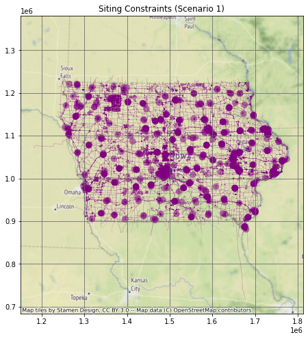
fig, ax = plt.subplots(figsize=(8, 8))
siting_constraints_2.plot(ax = ax, markersize = .1, color = "purple", alpha = .5)
ax.grid(True, color = 'dimgray')
ax.set_title('Siting Constraints (Scenario 2)', fontsize=12)
ax.ticklabel_format(scilimits =  [-5, 5])
ctx.add_basemap(ax, crs="EPSG:26975")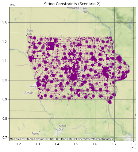
Wind Data
The table wind_cells_10000 contains 10 km2 square polygons with associated average annual wind speeds (m s-1), arranged to cover Iowa in a ragged grid.
sql_wind_speeds = \
"""
SELECT *
FROM
    wind_cells_10000
WHERE
    wind_speed IS NOT NULL
"""
wind_speeds = gpd.read_postgis(sql_wind_speeds, con = engine, geom_col = 'geom')
Results
Scenario #1
Subtract Siting Constraints from Wind Cells
suitable_cells = wind_speeds.overlay(siting_constraints, how = 'difference', keep_geom_type = False)Plot Suitable Wind Cells
fig, ax = plt.subplots(figsize=(8, 8))
suitable_cells.plot(ax = ax, markersize = .1, color = "purple", alpha = .5)
ax.grid(True, color = 'dimgray')
ax.set_title('Suitable Areas (Scenario 1)', fontsize=12)
ax.ticklabel_format(scilimits =  [-5, 5])
ctx.add_basemap(ax, crs="EPSG:26975")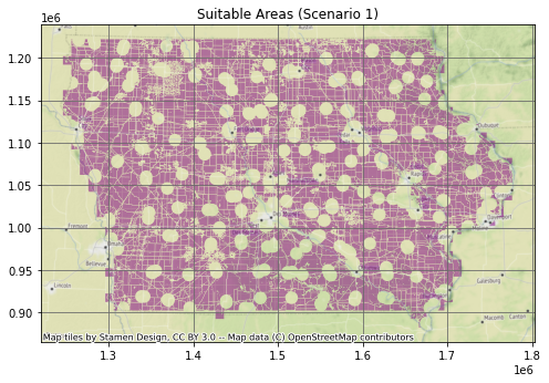
Find Number of Turbines
rotor_5x = math.pi * (136 * 5) ** 2
suitable_cells["area"] = suitable_cells['geom'].area
suitable_cells["number_wind_turbines"] = suitable_cells['geom'].area / rotor_5x
total_wind_turbines = suitable_cells["number_wind_turbines"].sum()
print("The total number of turbines in scenario 1 is:", round(total_wind_turbines))The total number of turbines in scenario 1 is: 57286Power production
suitable_cells['energy_per_turbine'] = 2.6 * suitable_cells['wind_speed'] - 5
suitable_cells['power_per_cell'] = suitable_cells['energy_per_turbine'] * suitable_cells['number_wind_turbines']
Total Power Production
total_scenario_1 = suitable_cells['power_per_cell'].sum()
print("The total power produced in scenario 1 is:", round(total_scenario_1), "GWH/year")
The total power produced in scenario 1 is: 1064159 GWH/yearScenario #2
Subtract Siting Constraints from Wind Cells
suitable_cells_2 = wind_speeds.overlay(siting_constraints_2, how = 'difference', keep_geom_type = False)Plot Suitable Wind Cells
fig, ax = plt.subplots(figsize=(8, 8))
suitable_cells_2.plot(ax = ax, markersize = .1, color = "purple", alpha = .5)
ax.grid(True, color = 'dimgray')
ax.set_title('Suitable Areas (Scenario 2)', fontsize=12)
ax.ticklabel_format(scilimits =  [-5, 5])
ctx.add_basemap(ax, crs="EPSG:26975")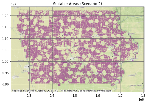
Find Number of Turbines
rotor_5x = math.pi * (136 * 5) ** 2
suitable_cells_2["area"] = suitable_cells_2['geom'].area
suitable_cells_2["number_wind_turbines"] = suitable_cells_2['geom'].area / rotor_5x
total_wind_turbines_2 = suitable_cells_2["number_wind_turbines"].sum()
print("The total number of turbines in scenario 2 is:", round(total_wind_turbines_2))The total number of turbines in scenario 2 is: 52055Power Production
suitable_cells_2['energy_per_turbine'] = 2.6 * suitable_cells_2['wind_speed'] - 5
suitable_cells_2['power_per_cell'] = suitable_cells_2['energy_per_turbine'] * suitable_cells_2['number_wind_turbines']
wind_speeds| id | geom | wind_speed | |
|---|---|---|---|
| 0 | 1 | POLYGON ((1256222.769 1212179.582, 1266222.769… | 9.336039 |
| 1 | 2 | POLYGON ((1266222.769 1212179.582, 1276222.769… | 9.097315 |
| 2 | 3 | POLYGON ((1276222.769 1212179.582, 1286222.769… | 8.984566 |
| 3 | 4 | POLYGON ((1286222.769 1212179.582, 1296222.769… | 9.266137 |
| 4 | 5 | POLYGON ((1296222.769 1212179.582, 1306222.769… | 9.296747 |
| … | … | … | … |
| 1437 | 1438 | POLYGON ((1686222.769 902179.582, 1696222.769 … | 8.678687 |
| 1438 | 1439 | POLYGON ((1426222.769 892179.582, 1436222.769 … | 9.114730 |
| 1439 | 1440 | POLYGON ((1656222.769 892179.582, 1666222.769 … | 8.237385 |
| 1440 | 1441 | POLYGON ((1666222.769 892179.582, 1676222.769 … | 8.423034 |
| 1441 | 1442 | POLYGON ((1666222.769 882179.582, 1676222.769 … | 8.109468 |
1442 rows × 3 columns
Total Power Production
total_scenario_2 = suitable_cells_2['power_per_cell'].sum()
print("The total power produced in scenario 2 is:", round(total_scenario_2), " GWH/year")
The total power produced in scenario 2 is: 967009 GWH/year